FableVision Learning Spotlight Blog
Categories
- Animation-ish 42
- Books 21
- Civics! 2
- Classroom Spotlight 17
- Conferences and Events 20
- Creative Educator 3
- Creativity 25
- Distance Learning 13
- Dot Day 22
- FabClassroom 28
- FabFriday 19
- FabMaker Studio 66
- FabMaker Studio Classroom 13
- FableFive 7
- FableVision Games 3
- Free Educator Resources 36
- HUTCH 1
- Home Activities 5
- In the Classroom 34
- In the News 11
- International Dot Day 23
- Ish 1
- Library 1
- Mapping the World by Heart 7
- Paul Reynolds 10
- Peter H. Reynolds 54
- Professional Development 9
- STEM/STEAM 20
- Storybook Academy 2
- Teacher Spotlight 14
- The Dot 17
- The North Star 2
- Words and Their Stories 1
- Zoombinis 3

Mapping the World by Heart Teacher Spotlight: Jessie Jung
This week’s FableVision Learning Teacher Spotlight was written by Jessie Jung, a teacher at Andrews Academy. For the past eight-years she has intermediate social studies.
“Teaching in an independent school affords a lot of curricular freedom, and our social studies program is ever evolving,” she explains. “We have chronologically organized our topics to span from the Age of Exploration in second grade all the way to the Civil Rights Movement in fifth grade. We have also worked to align our geographical studies with these concepts.”
In this post, Jessie shares a bit about how she uses David Smith's Mapping the World by Heart in the classroom and offers a few tips on how to get started.

How were you introduced to Mapping the World by Heart?
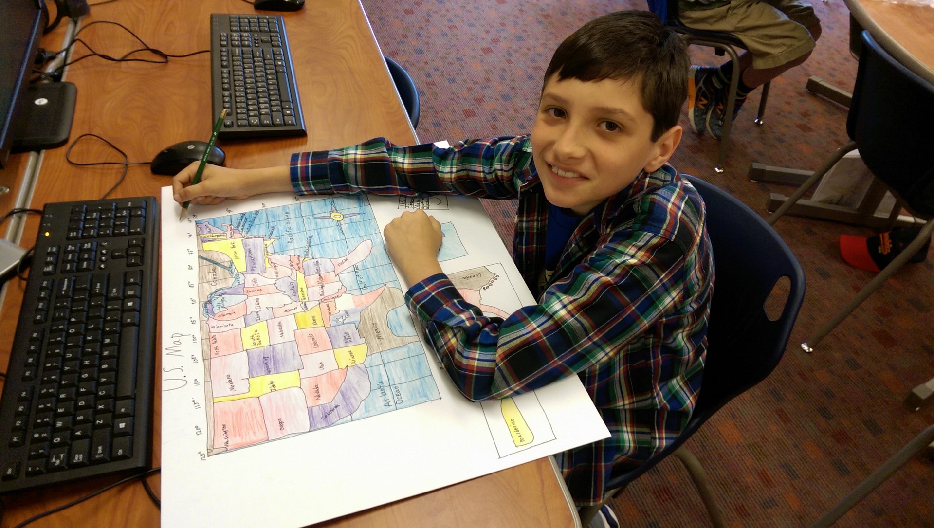
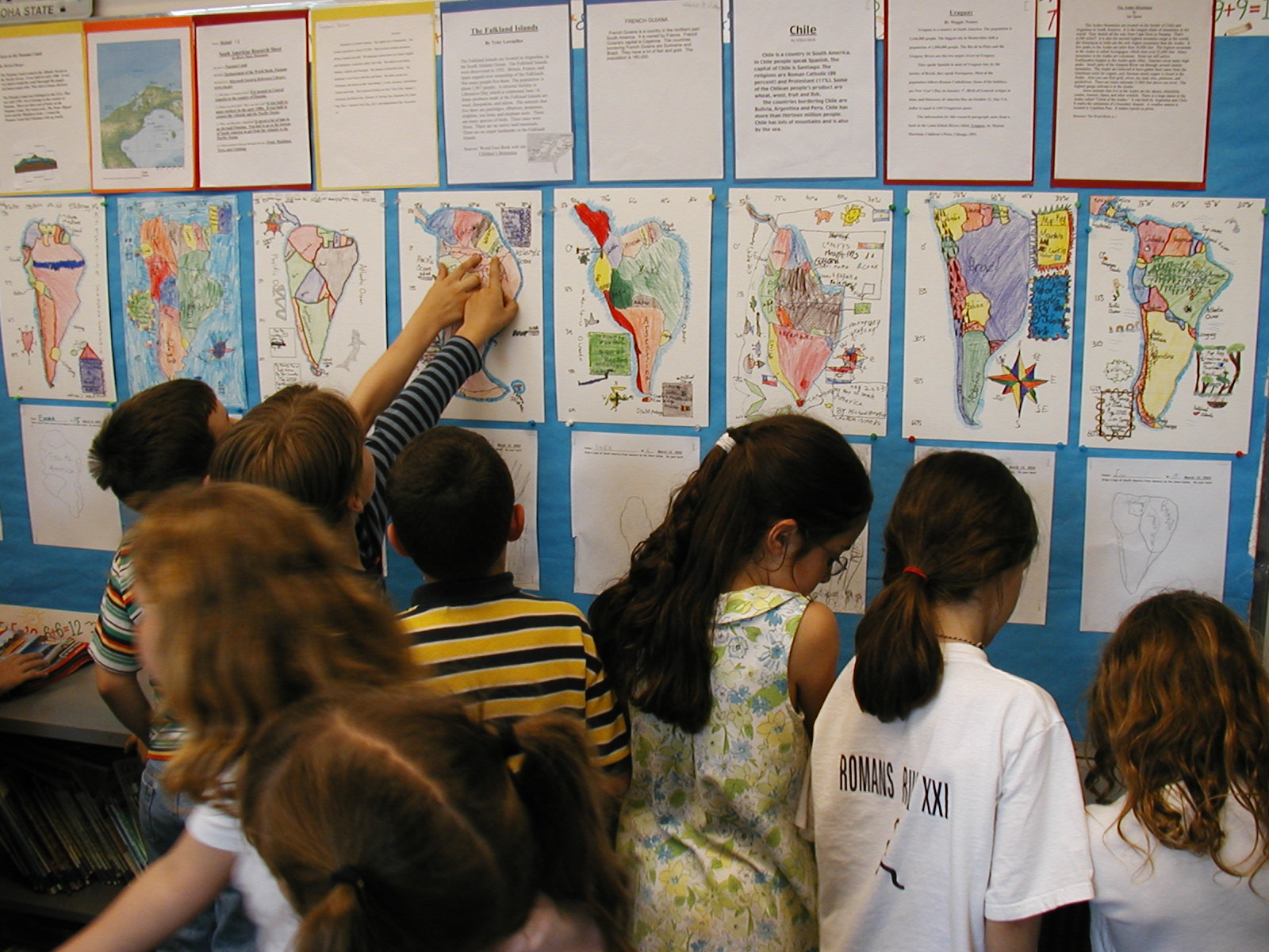
My friend and colleague, Nikki McGuire, brought the Mapping the World by Heart curriculum to our school a few years ago. She introduced the concept to her fourth grade social studies classes by having them map the United States by heart. The maps turned out beautifully, and we decided that just like our linear social studies curriculum, we would ultimately like to spread and spiral the mapping through several grade levels; mapping Missouri in third, the U.S. in fourth, Europe in fifth, and Latin America and the Caribbean Islands in sixth.
What makes the program different than other geography curriculum?
Mapping the World by Heart is a unique curriculum. It is very flexible and you can tailor it to your teaching style. You can make it belong to you and your students.
Every now again you get the “but do students really need to know this?” question. First of all, yes. I want my students to be globally focused. I realize we are only mapping Europe, but looking at life outside of our country makes us more aware that there are others inhabiting this planet. Secondly, being able to map requires using a totally different way of thinking than students are used to. It gives their visual-spatial intelligence and problem solving skills a workout. Think process not product! That being said…the finished product is something that students are extremely proud of.
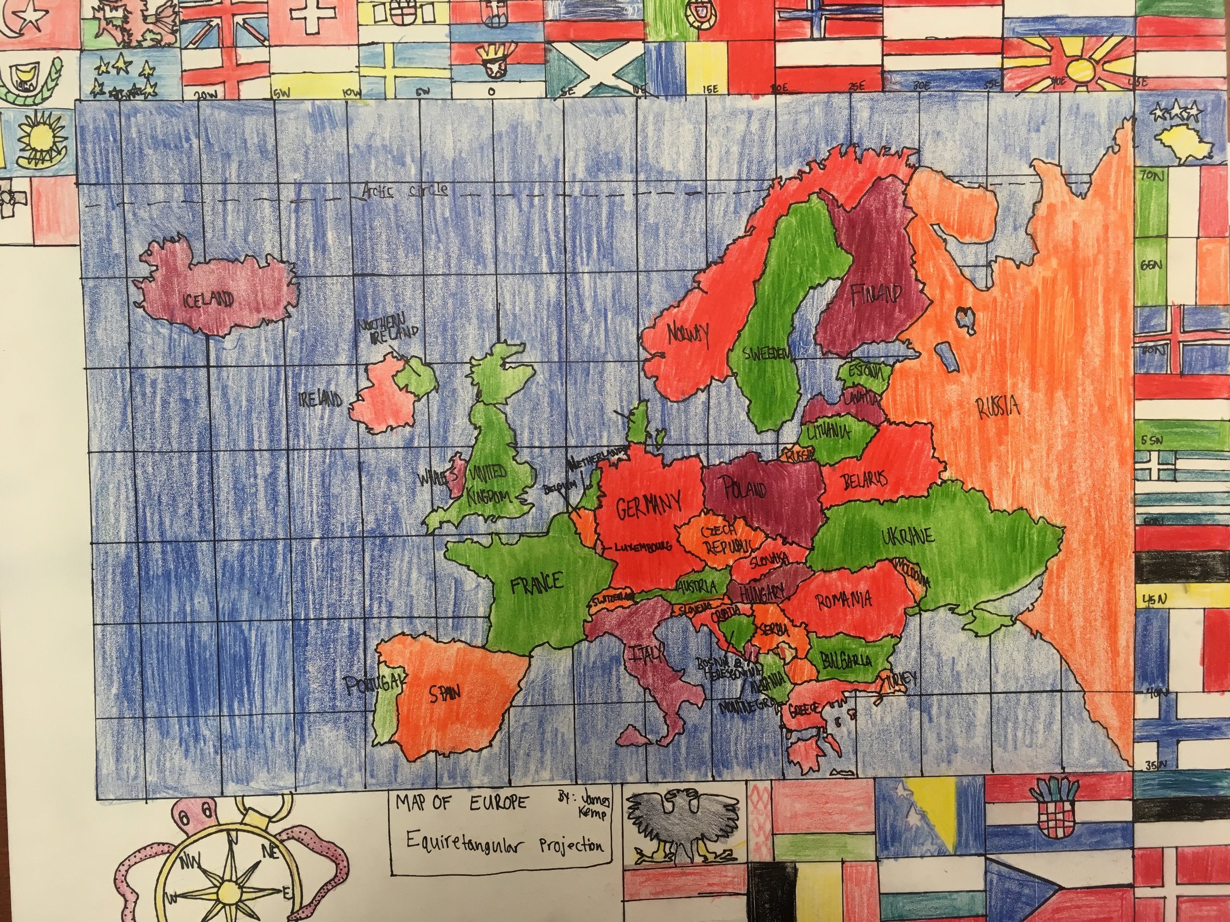
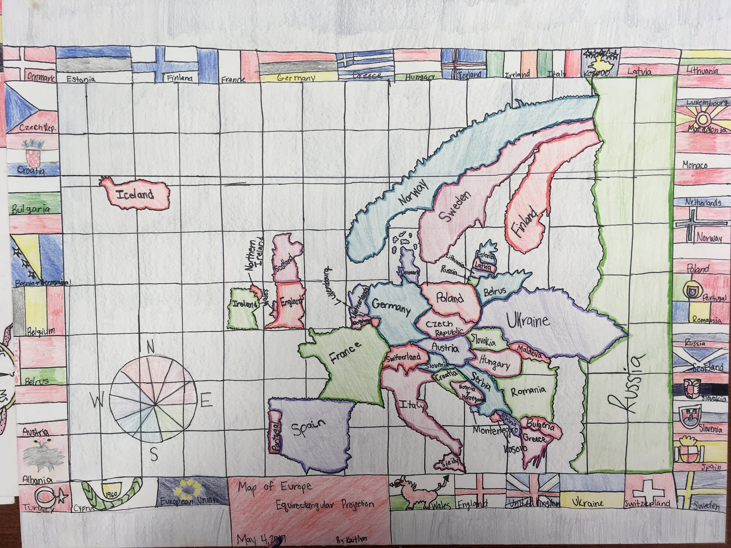
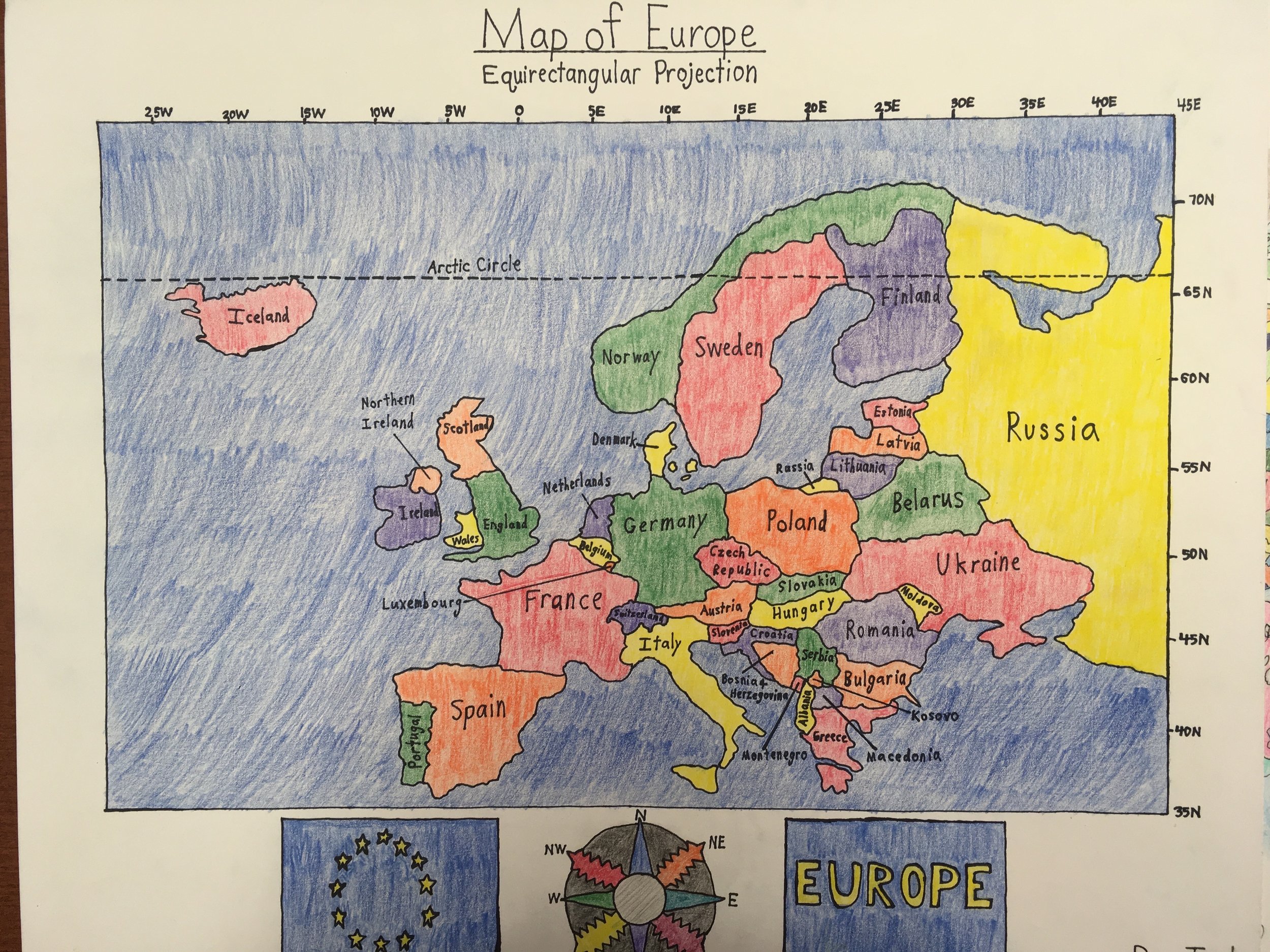
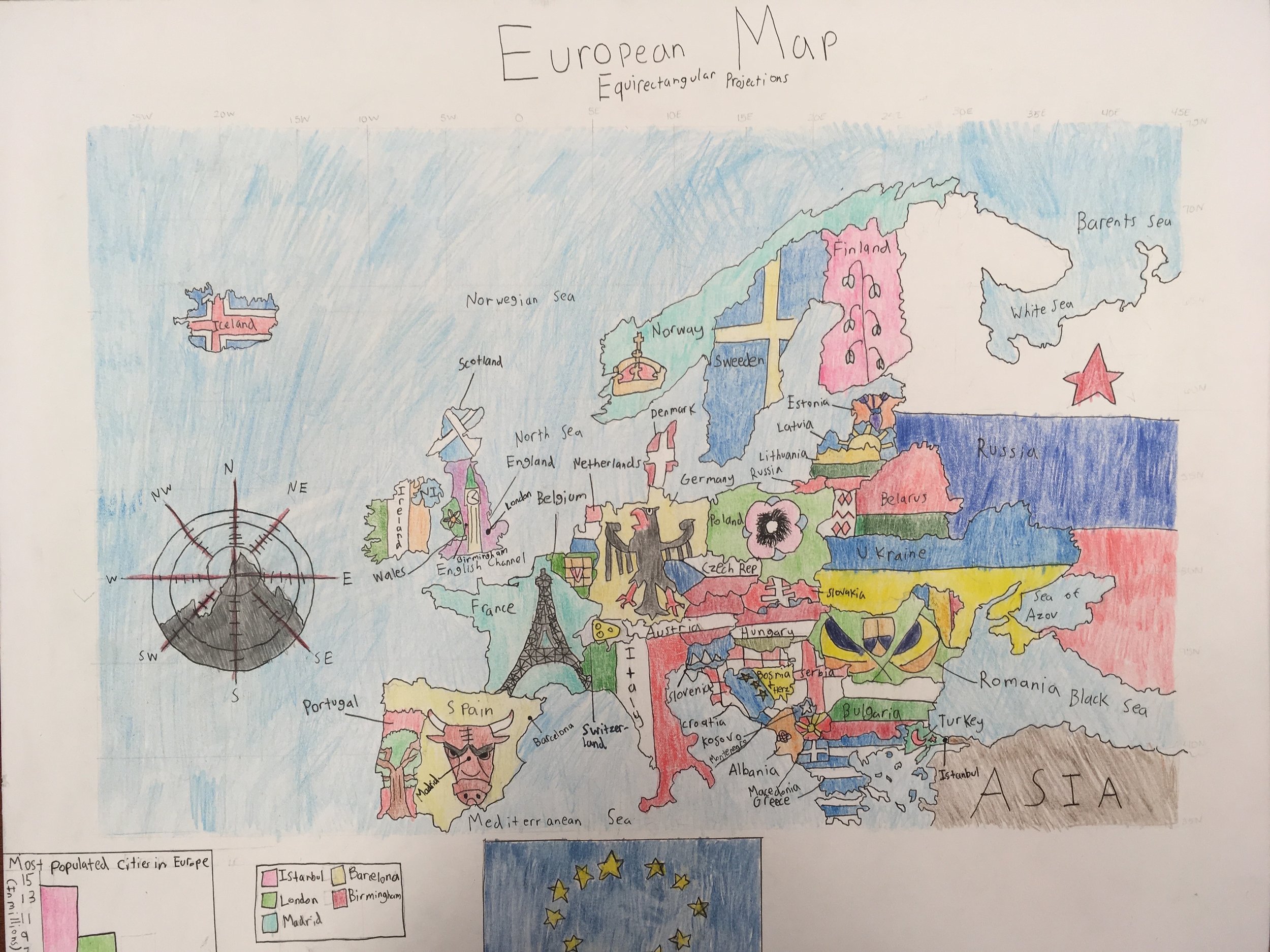
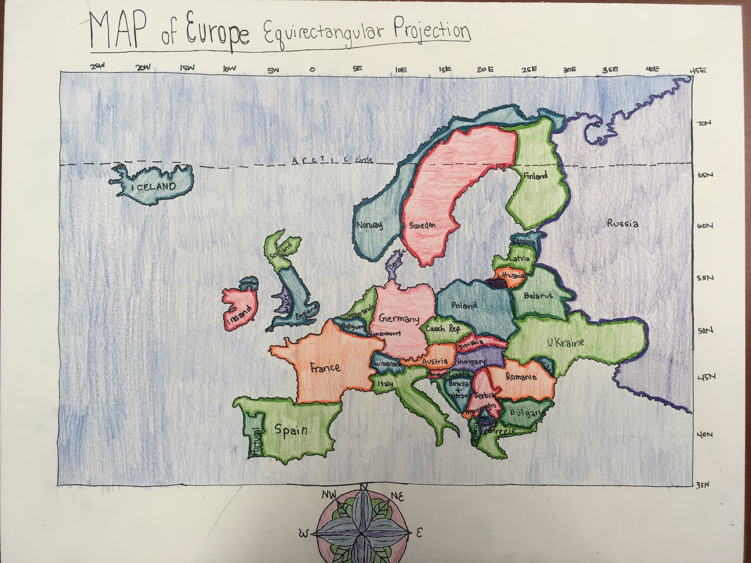
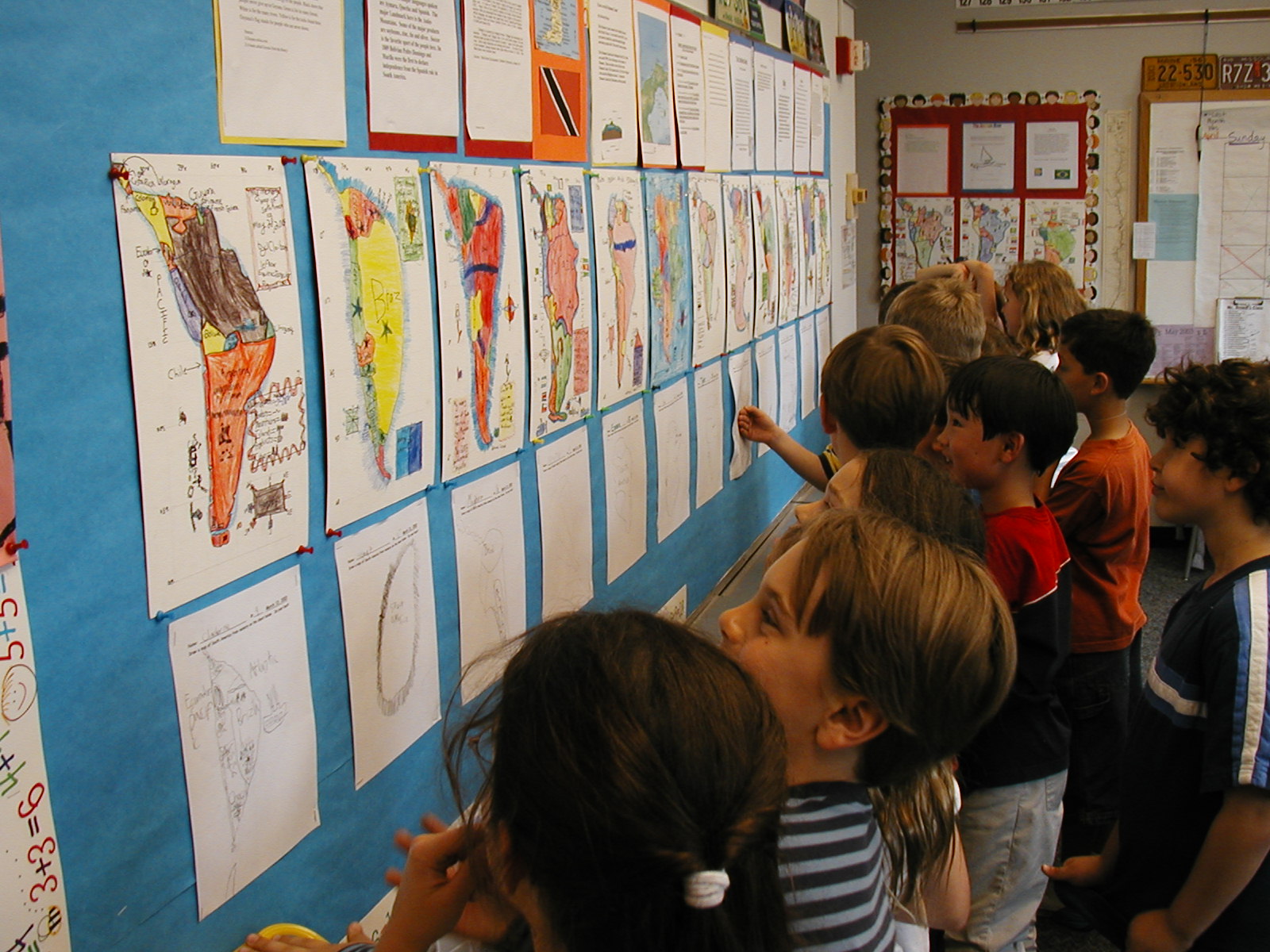
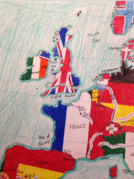
Many of my students channeled their artistic skills into their maps. A few students created a border of European flags around their map. Instead of coloring the countries a single color, another student drew a national symbol on each country. Some students included sea monsters, ships, and castles on their maps. Mapping was definitely one of the most memorable things that we did this year. In fact, several of the graduating sixth graders named mapping as one of their favorite things that they did in their school careers thus far.


How are you using the program in your classroom?
We decided that fifth grade would map Europe, which would dovetail into our units on World War I and World War II. The 2016 - 2017 school year was my first year mapping with my students. I had a couple of secret weapons in my arsenal; I had Nikki as a mentor, and my students had already mapped the U.S. the year before, so they had some serious prior knowledge. We began by memorizing the locations of the countries of Europe. We spent a couple of weeks splitting up the countries and creating memory devices to help us remember the shapes of the countries (Finland looks like a Fancy dress).
Then a few things became clear:
This was helpful for a handful of countries, but a lot of the European countries were pretty similarly blobby
The cost (time) was outweighing the benefit
I was stalling - it was time to jump into the deep end!
So we started with Iceland and the Arctic Circle, and we moved east. In the beginning, I really tried to cling to steering wheel, and have each student map each country together, but I had some students flying on ahead and other students still trying to perfect Iceland’s northern coast. So I let go. I circulated the classroom, looking for the key longitudinal and latitudinal markers to help keep the students on track. We broke the forty countries that we would be mapping into groups of ten, and then we mapped that section 3 times. Ten countries three times, followed by twenty countries three times, then thirty countries three times, and finally forty countries three times. We penciled and inked our final maps, created a color path, and transferred the color path to the final map.
What tips can you offer to a teacher starting out?
For teachers who are just starting off with Mapping the World, I would say, don’t be intimidated, it doesn’t need to be perfect. Your students will inevitably come out the other side of the program with more geographic awareness, refined problem solving skills, and a better sense of being a global citizen. For me, letting the program flow and evolve was key. Set manageable goals, and step them up each year. Get your students involved. Let them help you work out the logistics of the map.
What was one aha moment using Mapping the World by Heart?
Letting go was a big aha moment in this process. I am not necessarily a detail person, and I was stressing about using the curriculum as an exact science. Then I realized, I need to mold the curriculum to work with my strengths and my students’ strengths. I thought about what I realistically wanted for my students in this first year pilot program. I wanted them to know the European countries and their general shapes and locations. I also wanted them to surprise themselves and feel confident and proud of their maps. Realizing that this curriculum would be a process that would become more polished every year was key.
What is next?
Some of my fellow teachers test the students over their final map of Europe. This year, our maps were more of a project, and less of a memorized assessment. Next year, I plan to have students create three maps of Europe, a modern map, a map of Europe on the eve of WWI, and a map of Europe under Nazi occupation during WWII. The original map will be on tag board, and the WWI and WWII maps will be on tracing paper pages, laying over the tag board, illustrating the evolution of the continent.
Using FableVision’s books, media, and/or software in creative or interesting ways? Click here to nominate someone for the FableVision Creative Educator Spotlight and complete your submission electronically.

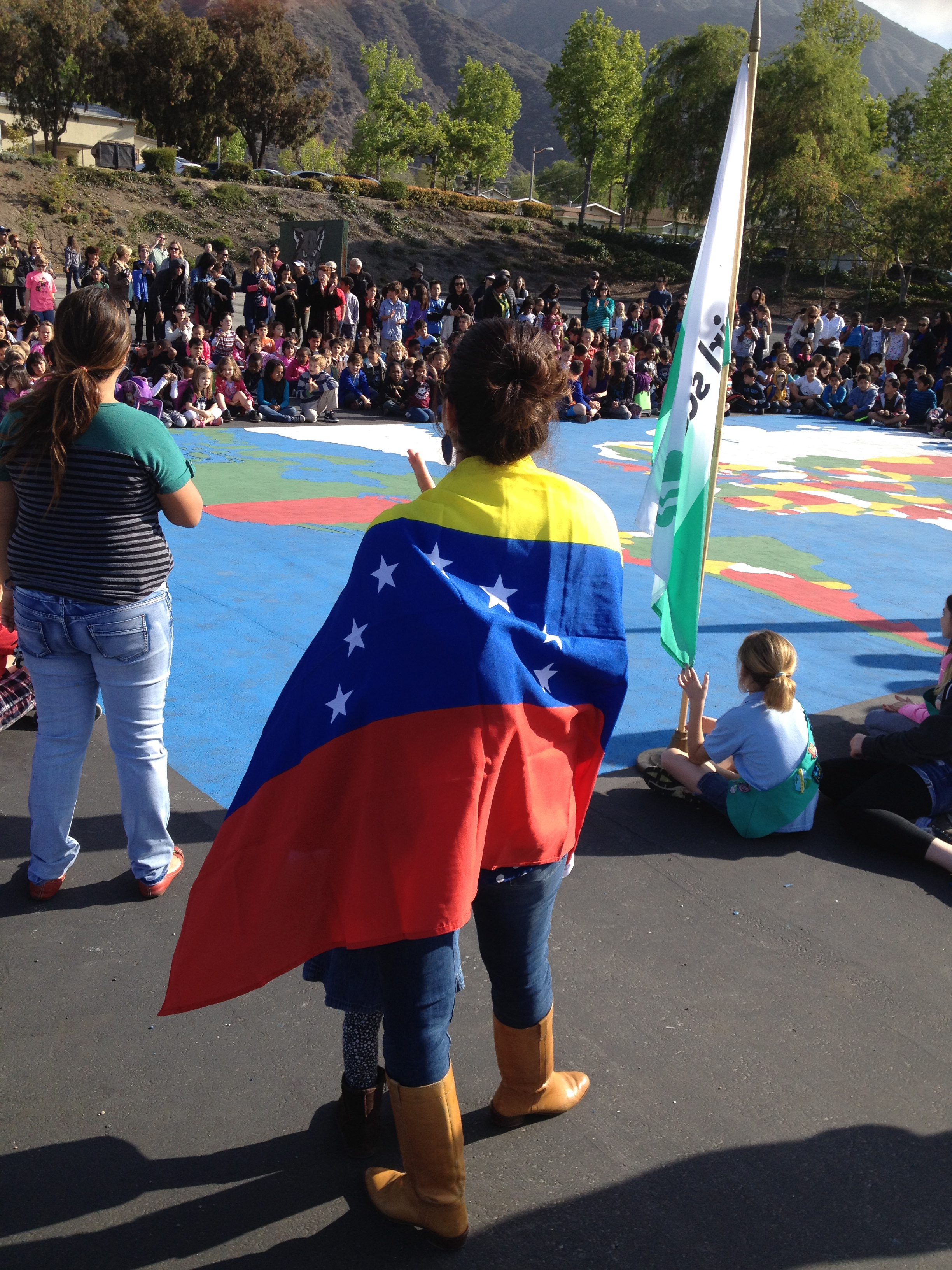
Mapping the World by Heart on Dot Day

There are 169 countries celebrating International Dot Day on September 15 — but where in the world are they all? One way to connect the dots this Dot Day is to map out the world from memory using David Smith's Mapping the World by Heart, paying special attention to the celebrating 169 countries!


To get you started on your International Dot Day mapping journey, here are 50 of the countries celebrating this year. Feel free to keep going and map the whole world though!
Can you map:
- Algeria
- Australia
- Bahrain
- Brazil
- Cambodia
- Canada
- China
- Democratic Republic of Congo
- Dominican Republic
- Egypt
- El Salvador
- Fiji
- France
- Germany
- Ghana
- Honduras
- Hungary
- India
- Iraq
- Ireland
- Israel
- Italy
- Jamaica
- Japan
- Kenya
- South Korea
- Laos
- Lebanon
- Libya
- Malaysia
- Mexico
- Morocco
- Netherlands
- New Zealand
- Norway
- Oman
- Pakistan
- Poland
- Qatar
- Russia
- Rwanda
- Saudi Arabia
- Spain
- Thailand
- Turkey
- United Kingdom
- United States of America
- Venezuela
- Vietnam
- Zambia

The award-winning curriculum is the creation of David J. Smith, a teacher with over 25 years' experience in the middle school classroom. Mapping the World by Heart is an innovative geography curriculum designed to inspire students to study - and love - geography. Through a combination of memorization and the real use of knowledge, practice, mnemonics, large and small group activities, and games, Mapping the World by Heart helps students thoroughly understand essential world geography.
Still want to learn more about exploring geography and joining the International Dot Day festivities? Click here to learn more about Mapping the World by Heart and click here to register for International Dot Day on September 15-ish!
FableFive: David Smith, creator of Mapping the World by Heart

“When our children leave our classrooms, we need to make sure they have a sense of their own community, and also an appreciation of everyone else's,” explains David Smith, creator of Mapping the World By Heart.

His award-winning geography curriculum gives students a means to picture the world beyond shapes on a page. Mapping the World by Heart provides a way to bring the world closer, because we can’t all travel the globe, but we can take steps to learn more about it.
David was a classroom teacher with over 25 years' experience teaching English, geography, and social studies in grades 4-12 and used that experience of teaching 7th graders to draw maps of the entire world from memory, to create his highly successful curriculum, Mapping the World by Heart.
When it was first released, Mapping the World by Heart was awarded the “Breaking the Mold,” by the U.S. Department of Education and to match the ever-changing world, David has revised the curriculum nine times since.
David is a full-time consultant, providing lectures and workshops on geography and global issues, and on IT issues, to teachers, parents, student groups, and others in the United States, Europe, Africa, South America, Australia, and Asia.
For this FableFive post, we connected with David to learn more about Mapping the World By Heart and the stories from the journey.


How did you connect the dots with FableVision Learning?
When Mapping the World By Heart was first published in 1992 by Tom Snyder Productions, Peter Reynolds did the illustrations and we became friends; when Tom Snyder was bought by Scholastic and MTWBH needed a new publisher, I called Peter (H. Reynolds) and he jumped at the chance to publish it. He’s done some new illustrations, and helped with all the prepress issues.
Can you share the story behind the creation and development of Mapping the World by Heart?

My grade 7 students in Cambridge, MA were sadly unaware of world geography, or even local geography. I didn’t want to send them onto their next teachers without helping them master at least some human geography and locations.
You speak regularly at schools in the US and Canada, can you share a few highlights from these visits?
I’m always happy when kids know my books, and have questions about them – and some of the questions are very common, such as “where did you get the idea for…” or “do you have to revise often”, but some questions can be surprising; “do the details about children living in hunger make you sad”, “how many countries have you visited”, and sometimes “how old are you."


Where do you see Mapping the World by Heart’s place in the classroom?
I don’t see it as necessarily the central activity for a classroom for the year, but as a very useful tool. If a class is studying US or Canadian history, or Asian languages or cultures, or European history, then mapping that region by heart can be useful for so much of what students will learn – the thing that is easy to forget is that history actual always happens somewhere. And knowing the human and political geography of a place can help a student understand what happened there.
Do you have any Mapping the World by Heart stories to share?

I’ve visited schools in 56 countries. At 10 of these schools, I’ve helped students prepare an outdoor playground map – of their country, their continent, or the world. At the International School of Windhoek, Namibia, the students created a map of Namibia in the entryway of the school; at the International School of Geneva, the youngest students, with their teachers and parents, created a world map in the main door to the playground – every time a student passes through that door, they have a chance to check out the world. The point is that the curriculum isn’t just about memorization, but it’s aimed at getting students to think about the world, about the world’s people and places.
Curious about how other schools are using Mapping the World by Heart? Check out these other posts!

Mapping the World by Heart Teacher Spotlight: Nikki McGuire
This week’s FableVision Learning Teacher Spotlight was written by Nikki McGuire, a teacher at Andrews Academy. In her 12-year career, she has taught at various schools in Missouri before settling at her current position. In this post, she shares just what makes David Smith's Mapping the World by Heart an invaluable tool in her classroom.

I was introduced to Mapping the World By Heart while teaching at the Forsyth School. My friend, Jim Dowd, fellow fourth grade teacher, coached me on how to bring mapping to life in my fourth grade social studies class. Forsyth had a memory mapping piece at the fourth, fifth, and sixth grade levels. Fourth grade learned to memory map the US, fifth grade mapped Europe/Africa I believe and sixth grade mapped the world by heart! I was amazed at how these students could learn to do this! It is incredible!

On the surface many people are quick to criticize Mapping the World by Heart as just memorization, but it is so much more. I have had many questions about what the use is, or maybe if it is just a waste of time. However, after mapping the US with 7 different fourth grade classes in two different settings, I can say it is one of the most rewarding teaching experiences! It is a wonderful process, but also an amazing product. Most of the kids frame them and hang them in their homes. They are a remarkable work of art! They will forever have those geographical ‘hooks’ to link future concepts of geography and history. It is well worth the time and effort it takes to teach and complete!

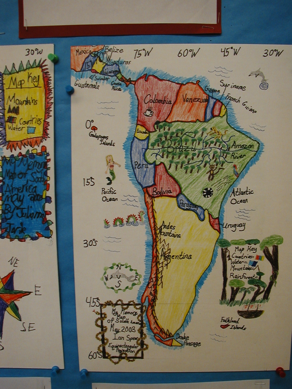
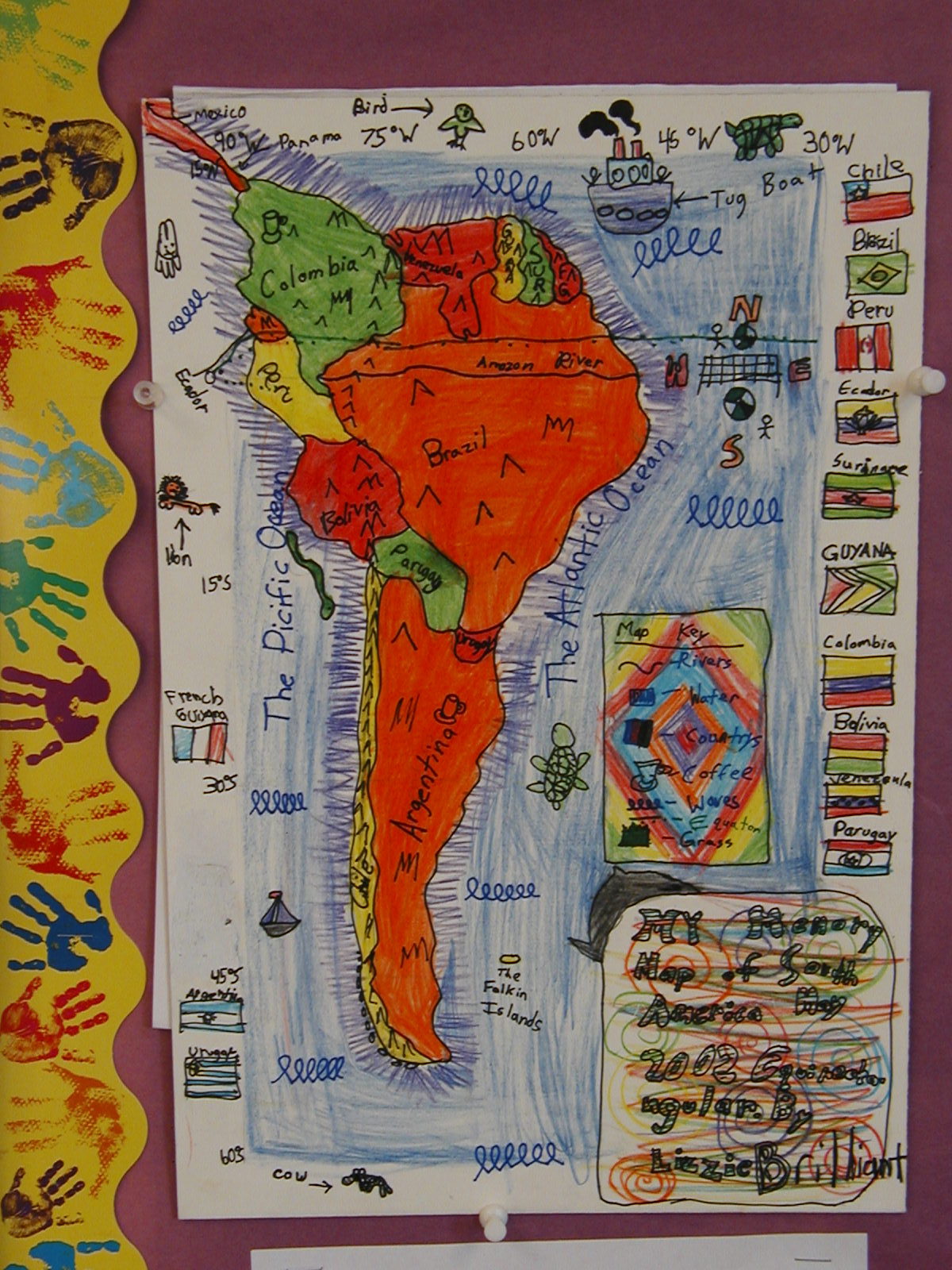
In my opinion, there are two types of memory mapping. One type is what I call "free drawing." That is where the shapes of states and countries are drawn in their proper location in relation to all the states or countries that border them, but it is not necessarily on the longitude and latitude grid system. The other is more precise and teaches the students to draw using the lines as guides, and really works to draw the countries and states in the "right" place. Both are beneficial. We use the grid system in tandem with free draw. The final map is done solely from memory, and takes place over 3-4 sessions, about an hour each. The students set goals and map to their goal. They are free to practice in between sessions or for homework, then continue on to their next goal.

I always begin the school year with a memory map which is usually really inaccurate! We save these maps and compare them to our final maps at the end of the year and then write about how it felt to draw from memory in August, versus in May. We spend several weeks working on map skills, memorizing the spellings or all the states and countries, and we complete many black line maps and test on the locations before we ever begin mapping lessons.
We talk a lot about different projections and how projections change the look of the map. Because I had never taught mapping Latin America, I did not have a longitude and latitude projection grid drawn out to use, so I decided to let my students plan one of their own after studying different projections. I played around with it and had a decent idea of a grid that would work, but one of my students figured out a great one, and it is the one we are all using! A lot of thinking, trial and error, and reasoning go into finding the right intervals, spaces, shape of rectangles, number of lines, etc. I was really proud of all the efforts made by my students. It really helped them understand how different projections can make your countries look long and thin, or short and fat, or too tiny, or too huge!

My biggest tip to anyone teaching memory mapping is to let go a little. Teach it in manageable chunks, and practice, practice, practice! Keep it fun, and don't be overly critical. Have the students take on the role of teacher. I also recommend that as you progress through the states, or countries, always draw them in the same order in the same way. In this way, it becomes almost rote. As you add chunks, always have them draw ALL the states up to the new chunk. For example, if you draw Washington, Oregon, Idaho...always start that way. When you add Montana, Nevada, California, always draw WA, OR and ID first, then add the next three, and so on.

I have found that the some of the most unlikely students will surprise you while mapping. Students with disabilities, little creativity or poor art skills often excel. Everyone can be successful with memory mapping!
Mapping the World By Heart Teacher Spotlight: Jim Dowd

The world seems strange and unimaginably big, but Jim Dowd has found ways to inspire his students to make the world seem that much smaller. This surprised even the parents in how effective his geography lesson plans worked.
“I would hear lots of feedback like, ‘I could never draw this map myself, and I can't believe that my 9-year old can!’ Parents would often frame the final map boards and hang them up at home,” he said about using David Smith’s Mapping the World by Heart curriculum in his classroom around the globe.

Jim’s teaching career spans continents. Working with the JET Program, he served as an English teacher in Japan. Back in the states he worked for an outdoor education program in St. Louis, MO and as a fourth grade teacher a Forsyth School in St. Louis, and a second grade teacher at the Latin School of Chicago.
He recently chatted with Fablevision Learning about his experiences using Mapping the World By Heart both in and out of the classroom.
How were you introduced to Mapping the World By Heart?
David Smith came to the Forsyth School in 1997 for a one-day teacher seminar. I had never heard of the program before, but I adapted his Mapping the World By Heart curriculum to fit my fourth grade USA-based social studies program. The students would do a memory map of the USA on the very first day of the year, and then draw all 50 states by memory in May. The difference in their geographical knowledge from September to May was mind-boggling!

Working with your students, you have mapped the world in many creative ways, can you share a bit about the playground world map?
As a PTA member at Don Benito Fundamental Elementary School in Pasadena, CA, I arranged for David Smith to come for an author visit. He met with the entire school and discussed his books and the importance of geography. Then the entire faculty, during a meeting, created the grid for a world Mercator projection map on the playground according to the guidelines in MTWBH.

The next day, students from each class came to draw a section of the world on the map. PTA parents and students then painted in the countries and oceans. After the map was completed, we had an assembly where parents and students born in different countries greeted the student body while standing on their home country. Don Benito has a very diverse student population, and I think we had about 30 countries represented. Teachers have since used the map to teach the locations of continents, oceans, and countries. Playing interactive games on a giant world map is much more engaging than looking at one in a textbook!

You’ve worked with students in elementary and middle school, what is the importance of teaching geography – and mapping – at a young age?
Unfortunately, geography is not studied formally in most schools anymore. Geographical and cultural literacy is so important when understanding the history of a time and place. Students who map the world by heart will know exactly where exactly where countries like Syria and Argentina are, while most adults have no idea.
What was one “aha” moment using Mapping the World by Heart?
My "aha" moment was when a students would tell me that they could never draw a section of the world by heart, but 8 months later they could do it. Another satisfying aspect of the curriculum for me was how parents would rave about the final mapping projects.
What’s next?
Now that my kids are approaching middle school, I hope to return to teaching full-time. I will definitely take a job at a school that will allow me to incorporate Memory Mapping to the curriculum, as it is always the highlight of the year!
Would you like to learn more about Mapping the World by Heart? Click, here.
Are YOU – or someone you know - activating any of FableVision’s books, media, and/or software to approach learning in more creative, engaging ways? If you'd like to nominate someone for the FableVision Creative Educator Spotlight, click here and complete your submission electronically.
Mapping the World By Heart Classroom Spotlight: Robin Clements

If you were to map Robin Clements teaching career, it would start and end with 8th grade. Currently an 8th grade teacher at St. Bernard’s School in New York, Clements is a “long-time admirer and even acolyte” of Mapping the World by Heart creator, David Smith. At every school, he has used the geography curriculum, Mapping the World by Heart, in his classroom to teach a number of different lessons besides just the borders of countries.
Clements said he caught the “mapping” bug in the early 1980s when he was headmaster at the Hillbrook School in California.
“(I) got the 6th grade teacher on board (and) she took Dave’s program pretty much as packaged for 6th grade history and geography, stretching it out over a whole year, with many activities of her invention to go with each phase,” he explained. They drew Africa as they were reading African folktales from different countries; their study of Asia was part map drawing, part culinary, and so forth. The kids loved it. At the end of the year, they drew the whole world in one mighty day, colored and decorated their maps and took them home to proud parents. It became a staple of our curriculum, a hallmark of our school.”
Moving across the country to the St. Bernard School in New York, Clements he got the green-light to do a seriously modified form of the map for 8th grade history and adapted Mapping the World by Heart to fit the curriculum.
“As the existing curriculum was medieval Europe, I found a conical projection of Europe that by chance included the Mideast, Northern Africa, and the countries of the Caucasus. The map was made into a desk-sized blank by a New York architect (who said getting the latitude right was one of the hardest things she had ever done), and I took the result to a printer, who did a thousand copies on cheap paper and fifty on heavy stock,” he shared. “We are still at it. Boys take about five weeks to learn the whole thing, starting with the water, then populating the blank spots with countries, capitals, mountains, and rivers. The guys get four class periods on successive days to draw and ink it. It took me about 10 years to figure out how to teach it and how to grade it, but I can now do it pretty easily.

You will see that it is not Dave’s pure idea at all, but it’s working well, most of the boys love the break from reading and essay writing, and there are often big surprises—the verbal genius who struggles with spatial relationships, the verbal problem who suddenly blossoms. It’s a different part of the brain. All in all, it’s been a success and I now have almost twenty years of victims to tell me how useful or un-useful it was. The consensus is quite useful in high school, and there are a couple of touching success stories.”
We recently connected with Robin Clements to share a bit about his work with Mapping the World by Heart in the classroom.
Can you share a bit about your career and you current position at St. Bernard's School?
I’ve been teaching just about forever—elementary school, college, high school—and was headmaster of a country day school in California for 21 years. I began with 8th grade as an apprentice at Hawken School in Cleveland in 1965 and it looks as if I’m going to end with 8th grade at St. Bernard’s School in New York. I’m a homeroom teacher with 20 boys and a couple of classes of medieval history, a couple of classes of Latin and a 7th grade geography class, plus all the homeroom stuff.
What is the role of geography in the classroom?

Heavens. It comes into every discussion if you give it time. I’ve got old-fashioned roller maps in a nest of four above the blackboard and I’m constantly changing them and reaching for one or another. In homeroom, we come to the Korematsu case—down comes the map so we can look at Hawaii, since the events started just after Pearl Harbor with a crash landing on Ni’ihau. Then on to the Bay Area, and finally Western Utah, where Korematsu spent most of the war. Pointing to spots on a map is so, well, old-fashioned, and yet I think it helps the boys remember the flow of the story.
We also have a good Internet connection, and there are endless uses. About how many people are there in Iowa? I have no idea, but Dr. Internet serves up the answer in a flash. One of the boys just wheels his chair around and looks things up. Google Earth is endlessly useful. Drawing the border between Jordan and Iraq raises the question of that little hiccup in the middle of a very straight line. Put it up on the board and let’s zoom in. Oh, look—it’s an airport, and the national boundary moves to keep it in Iraq. Geography ought to be as much part of elementary education as spelling or times tables.
What has been one aha teaching moment with Mapping the World by Heart?

You don’t mean things like “Hungary looks like a chicken,” do you? (And Ireland like a koala bear, and Switzerland astonishingly like a praying Muslim.) How about this: why does the western border of Armenia bend to the east? What is it avoiding? As you draw it, let’s talk about the history of Turkey and Armenia, a murderous hostility that finally deprived Armenia of its national symbol, Mt. Ararat. The whole story is something I knew only hazily before I began to teach the course, but it really pops out as you draw that line, and talk about the post-World War I war between Armenia and Turkey. Boys who draw this line are likely to tuck the story away, I believe.
Are you or someone you know using FableVision Learning’s creative tools for the classroom. We would love to feature them on our blog. If you'd like to nominate someone for the FableVision Creative Educator Spotlight, click here and complete your submission electronically or send us an email at info@fablevisionlearning.com
Mapping The World By Heart
Get to know "Mapping the World by Heart" by watching this animated video introduction! Author David Smith discusses this innovative geography curriculum.